The Geospatial Convergence: The Critical Role of Geospatial Data in Times of Humanitarian Crisis
Humanitarian crises come in many forms. But whether violence, water scarcity, famine, viral outbreak, or a natural disaster, they all share a common enemy: Geospatial data.
Crisis Management
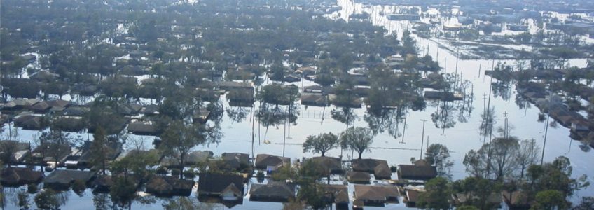
In a humanitarian crisis, knowing the lay of the land is critical, especially for field teams coming from outside the affected area. The CDC’s field epidemiology manual even lists generating generic maps as a primary step in crisis response set-up.
Understanding natural and built environments is crucial for setting up operations and delivering supplies. Meanwhile, deeper data integration, like population data, helps determine need and aids logistics.
GIS data is already a proven necessity in matters of supply logistics, given its ability to cross-reference diverse data like weather, road closures and conditions, and population data.
This becomes increasingly important in areas where non-government actors control swaths of territory. When there are no ‘official’ sources to turn to, satellite imagery and heat mapping, not to mention cell phone use tracking tools, can shine light into information dark zones. This capability can help supplies from falling into the hands of agitators rather than helpers.
Post Crisis Evaluation
In the aftermath of a crisis, geospatial data helps tell the world what happened. A grim example – GIS data has been used to map unmarked execution sites and mass graves by cross-referencing soil readings and plant growth patterns from similar sites in the past.
In her 2018 speech to GEOINT, Linking the World CEO Mina Chang put forth a clear vision of ways the geospatial and big data industries can empower humanitarian causes. The results, she postulated, could help prevent crises from arising in the first place.
The Future of Crisis Management – Prevention
Right now, organizations react to events that occur and funding goes toward fixing the situation, which Chang says is similar to treating a symptom but not the underlying disease. With the predictive power of geospatial data, this is a paradigm that could shift toward crisis prevention, rather than crisis response. The captivating visual nature of interactive maps may also spur donations toward preventative measures – much the way images of disaster inspire people to support relief efforts.
Analyzing a story map like the one, or the WHO’s ebola map, provides an invaluable window into the spread of a virus. This data is now used as a teaching tool for those who must respond to the next humanitarian crisis. Data-rich models can, as Chang says, give helpers a look into the future by analyzing past human and viral behaviors over landmasses.
Current Day Use Case
GIS logistics planning is already being used to combat the spread of COVID-19.
On March 30, 2020 at Mayo Clinic’s Jacksonville, Florida campus, autonomous vehicles began delivering COVID-19 tests and medical supplies.
To address the current pandemic on a global scale, there are tools like Esri’s COVID-19 Tracking Dashboard, which provides data to researchers, governments, aid workers and the general public in real time.
Key Takeaways:
- In current day, the use of geospatial data during humanitarian crises is critical for proper evaluation, tracking and response
- When there are no official sources to turn to, different forms of geospatial data, such as satellite imagery and population data, can be your only source of truth
- The focus needs to shift from humanitarian response to humanitarian prevention. By leveraging the ever-expanding geospatial databases and the many tools available, this vision of crisis prevention could become reality
- Interactive web-based maps can be an incredible tool for educating the world about the crisis whether that is real-time tracking or post-crisis evaluation and fundraising
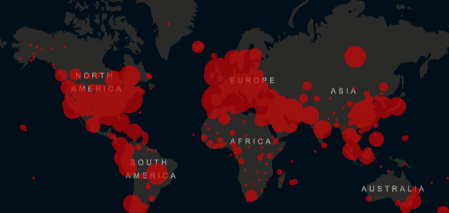
Image Courtesy of Johns Hopkins University.

The Geospatial Convergence: How Autonomous Vehicles Rely on Geospatial Data To Safely Navigate From A to B
Drivers need maps to get where they’re going. As cars learn to drive by themselves, they’ll need maps, too.
As transportation responsibilities transfer from humans to machines, clear, reliable data is essential. A human can differentiate between a map and its surroundings, but to the Artificial Intelligence running autonomous vehicles, the map data is their world. The more data-rich the map, the safer the vehicle’s cargo, whether commercial or human. Standard maps cannot give daily updates on construction zones or changes in laws and driving regulations, but maps powered with specific geospatial data can. Even information like parking ramp usage can be used to improve the user’s experience. The geospatial information industry, with its diverse data handling ability, is poised to empower autonomous vehicles to take the wheel.
Some of the largest companies in the world are making investments with an eye toward the coming autonomous vehicle boom. Amazon’s recent heavy investment into companies like Rivian and Aurora comes alongside a commitment to begin electric vehicle delivery by 2021. In the automotive industry, companies like BMW are making sure their big data departments, which are used to further the pursuit of autonomous cars, are staffed with geospatial data experts.
The future they are preparing for is coming fast. In late 2019, a Plus.ai self-driving truck transported a load of Land O’ Lakes butter from California to Pennsylvania (2,800 miles). () It navigated the entire stretch of I-15 and I-75 all on its own, without a single intervention from the onboard safety driver.
Interstate trucking routes are typically predictable, long, straight stretches of highway. For a more dynamic environment, enhanced detection and imaging abilities are required. Self-driving passenger cars need to know the size, shape, and position of unexpected obstacles. And they need these details regardless of the weather. Enter: LiDAR.
Light Detection and Ranging, or LIDAR, gives cars a 360 degree, 3D image of their environment, using laser beams to define its surroundings. They usually take the form of a cylinder on a car’s roof. Today, units are capable of 1.3 million readings a second to create an image. While radar beams detect things over a broad swath to determine weather or large obstacles, LiDAR can define things down to a shirt button.
As cars drive around with LiDAR sensors, terabytes of information are generated. This scanning data can be used in pursuit of better mapping information. And, in turn, existing geospatial data can also help determine the accuracy of labels generated by AI.
Once the new data is organized, test divers of self-driving cars are sent back out with a new combination of scenarios, synthetic data, and machine learning algorithms. Then the cycle begins again.
It may seem strange, but cars are about to have the same real-world expectations of what maps must convey as we do.

Animal Crossing: How Real-World Mapping Influences Nintendo’s Fictional Universe
Big news in the gaming world today- the highly anticipated game, “Animal Crossing: New Horizons” is being released! Though it may not be obvious, the geospatial field interfaces with the gaming world in many ways, even if the game is based in a fictional universe like it is in Animal Crossing.
One of the reasons this game has been so highly anticipated is due to the brand-new landscape and map options. In this version of the game, players are given their own island to explore and develop. Players will be presented with four different map options they can choose from, with each one having slightly different geographic features (different elevations, longer or shorter rivers, etc). Previously released images of the new maps (courtesy of Nintendo) show them to be quite simple, displaying only the necessary features- bodies of water, bridges, and a home base, among other things. Though the world of Animal Crossing is pixelated and filled with animal townspeople, the basic principles of mapping and cartography are still followed to a tee. Certain mapping conventions (i.e. water is blue, forest areas are green) have become so ingrained in what the collective expectation of a map is that there is often an adverse reaction from people if one of those conventions is not followed, even if the world is based on fiction.
For Animal Crossing specifically, the maps are predicted to start very simple and will likely get more complex as the player progresses and unlocks new features. This mirrors what happened with the earliest real-world cartographers- they made maps increasingly more detailed as they discovered more about their surroundings. Moreover, these maps became more complex as people found innovative and improved ways to capture, store, & use data. Nintendo went above and beyond to assure their gameplay mirrored the experience of being a real-life explorer. There have been rumors that there are many geologic features, such as cliffs and mountains, which will be discovered the more you explore the world, just as early trailblazers experienced. In fact, new discovery is still occurring today in places that are only just beginning to be explored, like the deep ocean and space.
There is a subset of video game design that is responsible for designing game maps, known as level design or environment design. While this entails much more than just designing fictional maps, displaying features on a map is crucial for positive gameplay experiences. These maps are often the first thing a player sees when beginning a new game and can guide players during in-game decision making. This is also true in the real world, maps can show a myriad of different features and can provide people with useful data that can aid in key decision making. A great example of this is how geospatial data is leveraged within insurance.
Whether the cartography is based on the real world or a fictional universe, almost all the same principles and conventions still apply. Our real-world expectations for what needs to be conveyed on a map have bled over into the world of simulation and gaming. As the games and features get more and more complex, so do the maps within the game experience, and, as a result, the gameplay experience itself becomes more immersive and enjoyable. It’s quite incredible to take a step back and realize how crucial maps are in our everyday lives. Whether you’re driving to a vacation destination using Google Maps or navigating the world of Animal Crossing: New Horizons utilizing their immersive map experience, there is always value to having a map on hand!
The Geospatial Convergence: The Many Applications of Geospatial Data in the Insurance Industry
At the nexus of insurance and geospatial information sits an important commodity: trust. People and businesses turn to insurers for protection in the event of a disaster. In turn, insurers look to reinsurance to protect themselves. In this swirl of individual policies, claims, disasters, and shifting populations, geospatial data brings clarity and actionable insights. For an industry operating on both global and local scales, the ability to track regional trends and apply them to individual policyholders has proven indispensable.
From health insurance to risk analysis, event monitoring to route planning, the insurance industry uses GIS, Satellite Imagery and various other geospatial inputs and technology to go beyond static figures and spreadsheets. The clearest examples may be with risk assessments where geospatial technology is leveraged to better assess risk across time and space.
For example, in an area affected by frequent power outages, insurers can use past outage trends to predict where future ones might occur, down to individual buildings utilizing GIS. This allows for a more strategic policy offering, tailored to the specific risks of an area. Geological data can be used to evaluate earthquakes and natural risk hazards, determining whether a repeat catastrophe in that area is likely.
The same goes for crime – home insurers can integrate their location information with that of the nearest police station’s activity, giving a clearer picture of the pattern of crime. Property values can be folded in, too, by linking with real-estate marketplace services.
The one commonality amongst all the various use cases in the insurance industry is the demand for accurate and constantly updated data. East View Geospatial is the sole provider of one of the best tools on the market, the LandScan Global Population Database. Developed by the Department of Energy’s Oak Ridge National Laboratory, LandScan is the industry standard for global population distribution. It is the world’s most accurate spatially referenced ambient population distribution model and features the finest resolution global population database. This provides insurers with critical location-based insights. The database is updated annually reflecting improvements in source inputs and algorithms. What does this mean for insurers? Quick and simple assessments, estimates, and visualizations of populations at risk.
Population data like LandScan is extremely valuable to the health insurance industry, too. In places that require health insurance, city officials can use GIS to pinpoint areas of low coverage within a city, even making predictions based on factors like income, health, and age. This is more than just a benefit to insurers – the refining of risk factors helps identify areas where the population may be more susceptible to an outbreak or specific illness.
Customer service-wise, the heightened ability to anticipate the aftermath of a disaster based on past events, while simultaneously following events in real time, gives insurers the capability of immediate action. Using imagery and geospatial data means customers can get their claims faster, and recovery can get underway sooner. With the power of objective geospatial data behind that decision-making, the outcome can be trusted, not contested.
The Geospatial Convergence: How Geospatial Data is Being Leveraged Like Never Before
Part 1: The Convergence of the Geospatial and Gaming Industries
From driving directions to complex industrial projects, geospatial data helps shape the way we interact with the physical world around us. Thanks to the gaming industry, it has seeped into life’s imaginary aspects, too. That convergence of fun and utility has led to important innovations and a fascinating future, and even given people a glimpse of the way the world looked in ancient times.
From the Tony Hawk Pro Skater series, which recreates famous skateboarding spots from real cities, to Grand Theft Auto, which creates fake versions of real cities to wreak havoc upon, games today revolve around maps. They nearly always have – working memory of the 2D Super Mario maps was how to win that game. But today’s video games and virtual simulations are rapidly approaching the level of detail and immersion of the real world.
East View Geospatial’s 3D modeling and building databases give users access to spatial information about specific points on the globe, like where buildings, roads, and other built-up features are. Combined with our capabilities in terrain and elevation modeling, the result is an astonishingly detailed reproduction of real-life places, right down to trees, bushes, streetlights, and telephone poles.
That’s the kind of data that helps make the post-apocalyptic versions of real cities in the Fallout game series believable. In fact, much of the acclaim for that game’s details comes not from the famous landmarks it portrays, but from the realistic depiction of neighborhoods flush with real-world details – even down to the size and color of bricks on a wall. The same goes for Metro 2033’s faithful reproduction of the Moscow Metro system. The stations in Moscow are known (in real life) for their ornate stateliness. In the game, their degradation is used to immerse players in the grim imagined future it sets up.
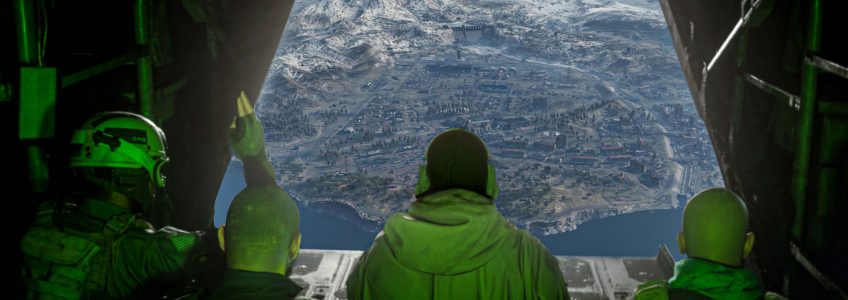
Those are the kinds of environmental details that keep gamers immersed in the world made by developers. And they are not limited to modern environments anymore. Thanks to the application of geospatial imaging processes to archaeological information, the creators of the Assassin’s Creed games recreate ancient cities and buildings with astonishing accuracy. For Assassin’s Creed: Brotherhood, the team created a 1:1 virtual reconstruction of Rome’s Colosseum. The Call of Duty game series recreates both current and historic battlefields. In the recently released Port of Verdansk Map in Call of Duty: Warzone, geo-specific data was utilized to create a gameplay map from the city of Berdyansk, Ukraine. The incredible detail around the port and within the entire gameplay experience allows players from all corners of the world to be immersed in a real-life landscape.
Techniques like photogrammetry, which allows for a kind of composite rendering to be made of individual 2d photos, make the possibilities even more tantalizing when it comes to archaeological exploration.
For processes like that, East View Geospatial’s sourcing and consulting abilities are second to none. Our procurement teams track down and obtain the most accurate, geo-specific data for our customers’ end-use needs.
Our confidence in our abilities comes, in part, from working with the defense industry for the last quarter-century. We’ve earned our expertise in situations where accuracy matters most.
However, without advances made by video game graphics, GIS simulations and data presentation would not be as close-to-reality. That’s why the convergence of these industries promises to continue giving both important -and- entertaining results.
At East View Geospatial, we are excited to be working at the cutting edge of information that allows interplay between virtual and physical realities. The implications, in worlds both real and imagined, are immense.
(Image courtesy of Activision)


