The Bright Future & Potential Impacts of SAR
As SAR data becomes more affordable and accessible, the geospatial industry will adapt with it. Just how precisely SAR’s impact will be felt remains a big question mark at this stage. Nonetheless, the excitement is palpable. Still, plenty of new technology gets hype and fades away; what makes new tech become standard tech is its ability to replace what came before it.
SAR has that ability, considering its edge over optical imagery with regard to weather factors and nighttime imaging capabilities.
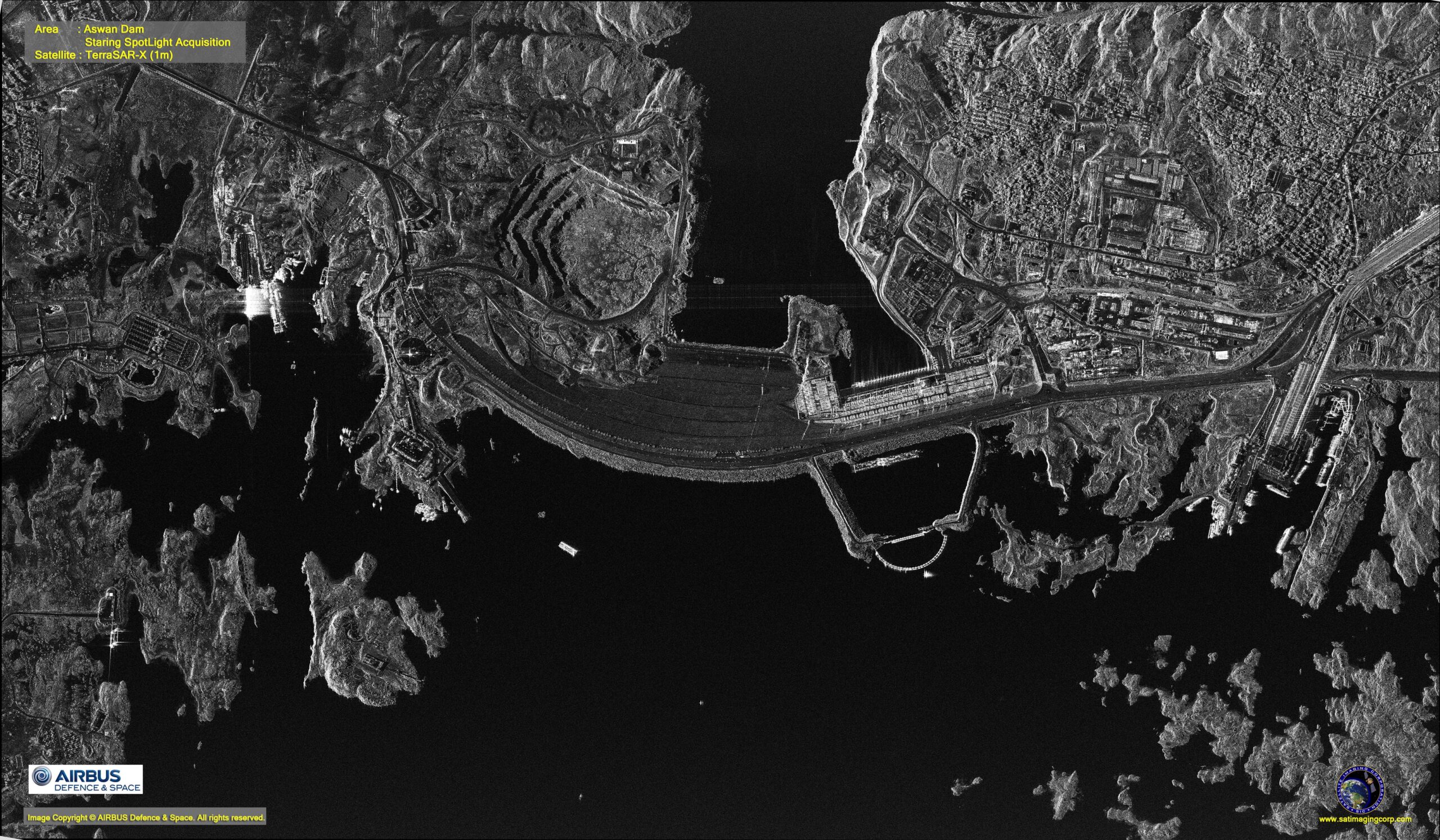
SAR image of the Aswan Dam in Egypt. Image courtesy of Satellite Imaging Corp. and Airbus Defence & Space.
For years, SAR technology and data was mostly in the domain of governments. Its capabilities and usefulness have been well-proven, but principally for entities with enormous resources at their disposal. For example, imagery analysts from National Geospatial-Intelligence Agency (NGA) design workflows to regularly ingest SAR and make it useful. But that is only beginning now in the private sector.
Thanks to companies like Capella Space, which is continuing to launch its own constellation of SAR microsatellites, the technology is starting to creep out from behind government curtains.
East View Geospatial is an early reseller in North America for Capella Space, which now has the highest resolution commercial SAR imagery in the world. Four months ago, Capella launched its first operational satellite, Capella-2, a 107kg microsatellite that enters space the size of a washing machine before transforming in orbit. Data from that satellite is capable of producing 50 cm x 50 cm radar images – a level of detail that, when coupled with worldwide tasking capacity, unlocks even more potential and opportunities.
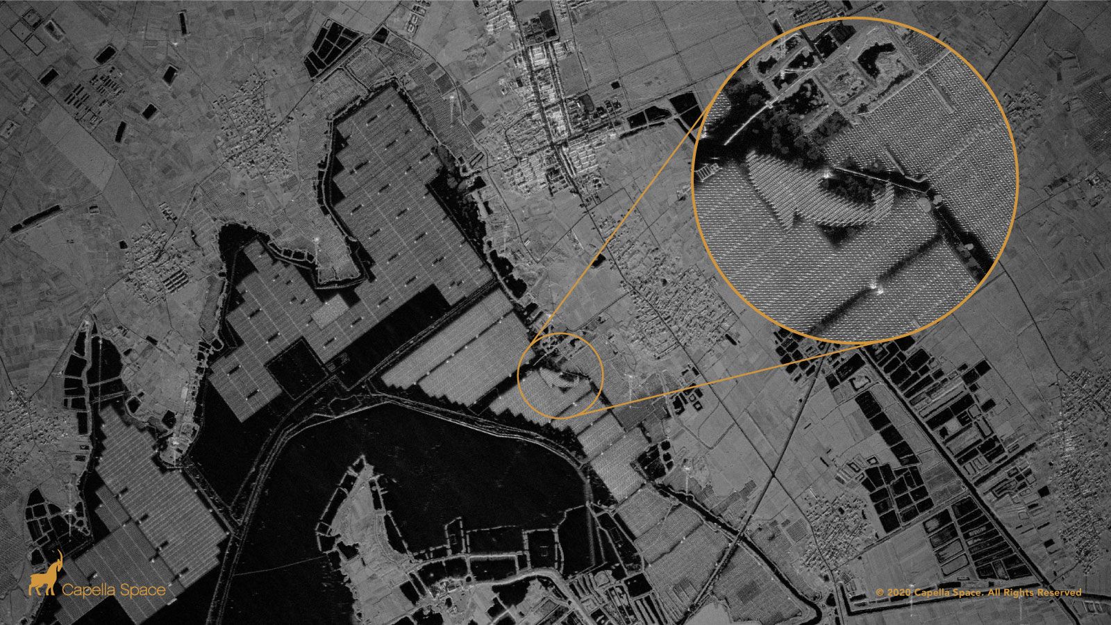
A SAR image of Tiangang Lake Solar Farm in China. Image courtesy of Capella Space.
The most obvious opportunity is nighttime imaging. Current commercial satellites are designed with sun synchronous orbits that generally image during peak sunlight hours – 10:00 a.m. or 1:00 p.m. This leaves tracking of nocturnal changes and information difficult to procure. With SAR satellites dotting the sky, capabilities for nighttime research and data collection, we believe, will blossom.
The shift will not occur overnight, however. Most industry professionals are trained in optical imagery and will have to learn to use SAR and the analytical tools associated. As companies like Capella launch more and more satellites, though, we predict an explosion of research and development around SAR data and analytics. This will eventually lead to academics crafting new theories and testing new applications, and on the commercial side, companies developing new and innovative tools for big data and SAR-focused algorithms.
SAR: Seeing Beyond the Visible
The ability to ‘see’ through darkness and weather events from space makes SAR data an invaluable asset in wide ranging endeavors from tracking changes in topography to sharpening responses to cyclonic storms, floods, earthquakes, oil spills, and other disasters.
Most recently, satellites operated by NASA’s Jet Propulsion Laboratories are providing SAR data for NASA’s effort to ‘see’ the COVID-19 pandemic from space. The initiative tracks changes in human activity as lockdowns are enacted and lifted across the globe.
This is a prime example of SAR data’s ability to enhance change detection capabilities. Because human activity occurs more or less regardless of light or weather conditions, optical data alone falls short in this project. SAR data’s unblinking look at patterns of human movement over a period of time, however, offers clear benefits.
SAR data is also capable of tracking change over much shorter periods of time than the recent lockdowns. In 2015, days after an 8.3 magnitude earthquake shook Chile, Alaska Satellite Facility scientists used SAR data from the Sentinel-1A satellite to create an image depicting an 8.5 cm line-of-sight motion.
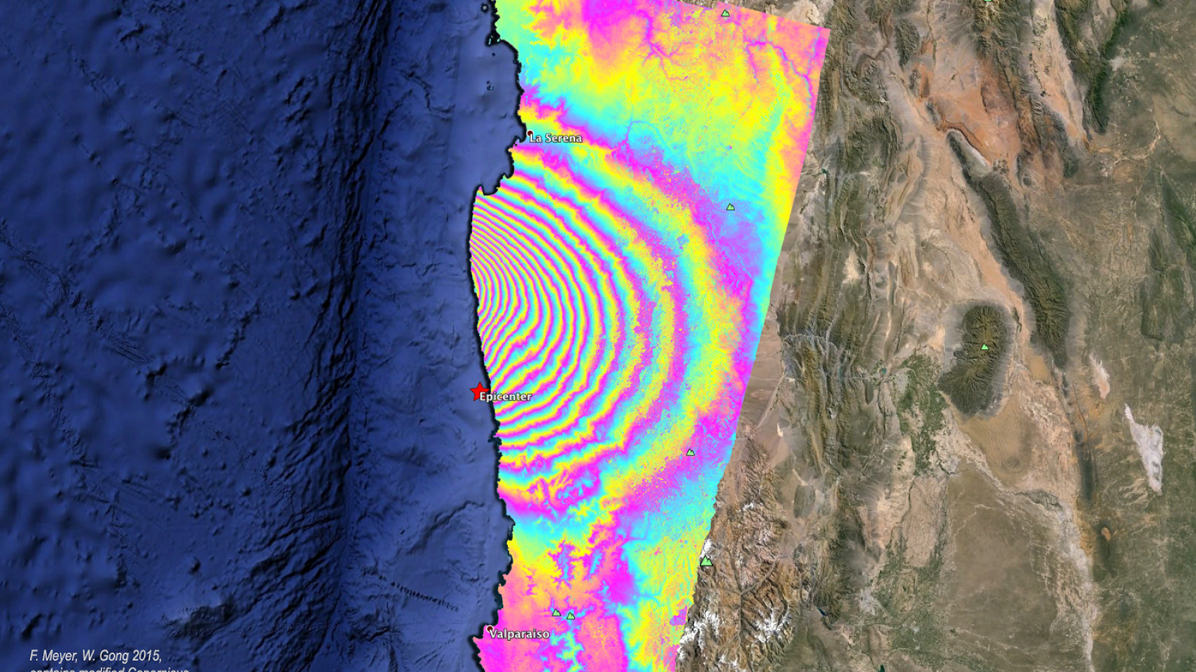
Image courtesy of The Alaska Satellite Facility, F. Meyer, & W. Gong (2015)
In 2010, SAR technology was instrumental in NASA’s efforts to support responses to the Deepwater-Horizon oil rig blowout. The data was used to (among other things) characterize oil in open water and track its progress toward coast and marshlands. In this instance, too, the ability to function irrespective of sunlight or weather is a clear and sound benefit.
That ability does come with some challenges. Namely, raw SAR data contains noisy images that require training and software to overcome. As more SAR data makes its way into the hands of users and experts, however, processes are being developed to make SAR data increasingly useable for those who have questions it might answer.
Studies, like this one by the Remote Sensing Division of Instituto Nacional de Pesquisas Espaciais, Brazil, work to alleviate issues of stabilization when imaging forests. That work enables faster progress on early warning systems for deforestation, which are key components for governmental forest reduction policies.
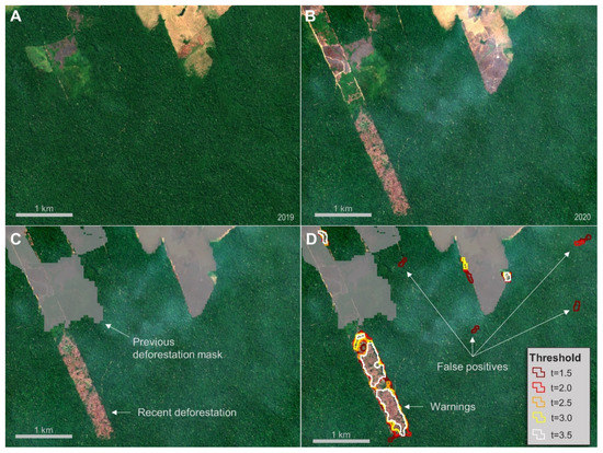
A figure showing how SAR data is used to detect deforestation in the Amazon. Image courtesy of Remote Sensing Division of Instituto Nacional de Pesquisas Espaciais.
Another clear example of the progress being made is SAR data’s ability to analyze icebergs. In 2007, researchers tracked sea ice in the Bering Strait with RADARSAT-1 data. A decade later, processes around deep learning and SAR data made even more detailed analysis possible. In October of 2017, the Statoil/C-CORE Iceberg Classifier Challenge contest used SAR data to help ‘machine learn’ the difference between icebergs and ships as part of an effort to drive down the cost of operating safely. In a similar challenge, efforts utilizing data fusion are underway to map power grids.
As innovations by experts cause end-user costs to fall and accuracy to rise, we can’t help but wonder what the growth of SAR data means for industries far and wide. Next week’s post will explore some of the technology’s potential impacts and legacies.
Synthetic Aperture Radar (SAR) 101: Taking Imagery to the Next Level
Synthetic Aperture Radar, or SAR, sees through things that neither the human eye nor electro-optical methods could ever hope to.
Seasat, the first satellite bearing SAR, departed Earth from the Vandenberg Space Launch Complex in California on June 28, 1978. In the decades since, constellations of SAR satellites have been launched and now orbit the planet, taking in data with uses ranging from measuring tiny daily changes in oceans to monitoring economic infrastructure use and aiding disaster relief efforts.
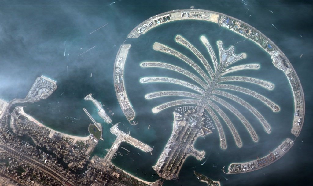
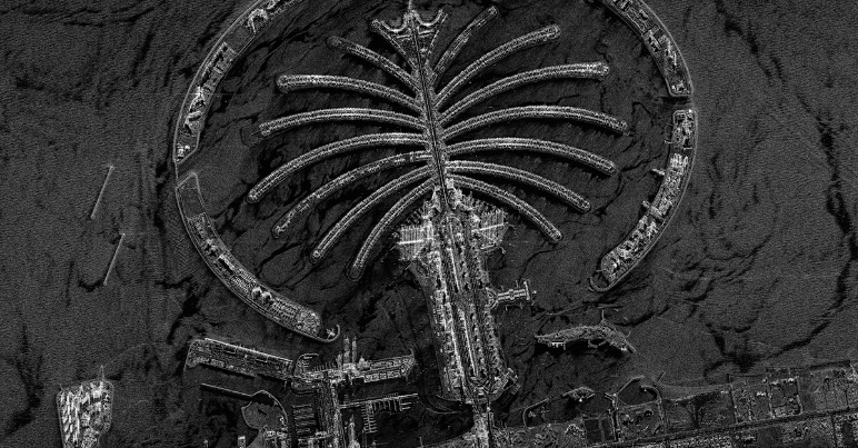
A satellite image compared to a SAR image. Images courtesy of the Dubai Media Office (left) and Capella Space (right).
Like infrared, SAR can penetrate below old barriers like soil, ice, and vegetation. The difference becomes apparent when weather (or worse) rolls in. Traditional electro-optical sensors are rendered blind by clouds, smoke, and at night. SAR sensors are not. They can perform overhead collections in all weather and illumination conditions. A change map that updates as fires rage is a powerful tool against increasingly destructive wildfires in the western United States; the same could be said for oil spills in storms or flooded cities with ongoing rain.
SAR is able to penetrate these things because they are active sensors. The pulses they emit ‘illuminate’ the ground or other surfaces using microwaves. Optical sensors, by contrast, are passive, and rely on sunlight reflecting back from the earth’s surface, which can be blocked by clouds, etc.
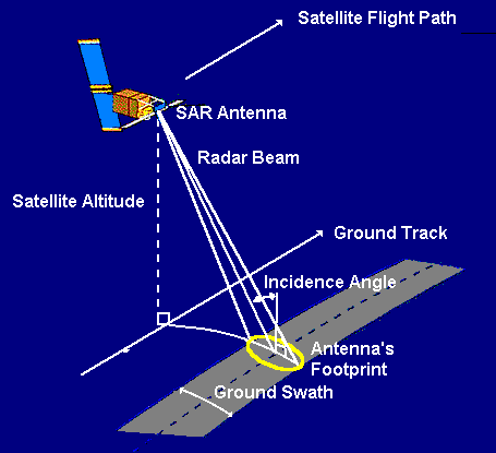
SAR satellites emit their own electronic apertures. These apertures send out pulses and measure the phase, intensity, and time it takes for the signal to return after bouncing off a surface (see diagram to the left, courtesy of Centre for Remote Imaging, Sensing & Processing). Though phase does not resemble traditional imaging data, it collects displacement and height data (another capability optical sensors do not have) and this is useful for interferometry and polarimetry.
SAR shows visual characteristics based on backscatter, which detects change and surface texture. There are three kinds of backscatter; each tells its own story.
Diffuse, or rough, backscatter, indicates mountains or other terrain. Specular reflections occur when a pulse bounces off of a smooth surface, like water or pavement. These regions appear dark in visualizations. Double bounce backscatter is prevalent in urban environments; it occurs when a specular reflection is interrupted by a building or other structure on its way back to the satellite. This results in bright pixels.
SAR instruments use a wide range of band frequencies which determine how the data can be used. Longer wavelengths/lower frequency SAR signals can ‘see’ through matter like vegetation and soil, for example. The frequencies also determine what size features SAR data picks up on. The size of the wave correlates to the size of the object it is supposed to sense; high-frequency bands ‘see’ details like leaves on a tree, while lower frequencies ‘see’ that same tree’s trunk.
The result is a wide range of available scales – from 0.5 meter to 200 km. As a wealth of SAR satellites now inhabit our skies, more and more data is available for free, though much also remains private. This data can be processed in an array of software, from open source tools to standard commercial software like ArcGIS, Gamma, ENVI, and others.
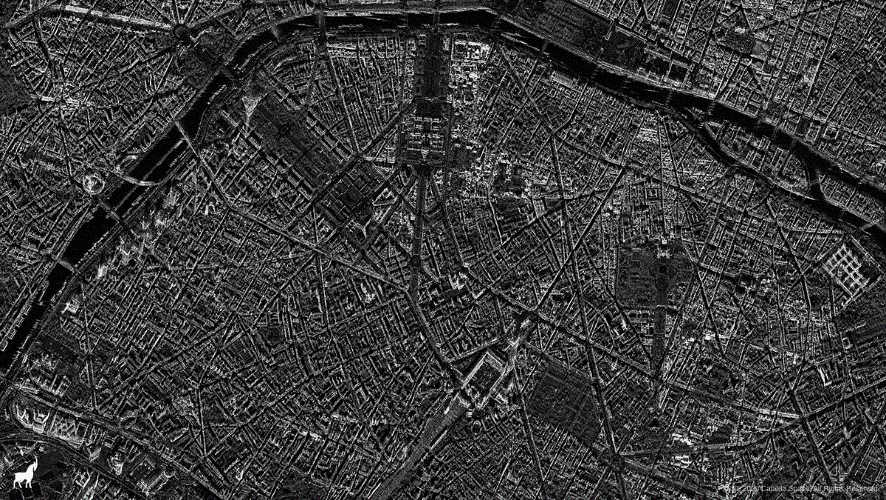
A SAR image of Paris. Image courtesy of Capella Space.
SAR and EO data can also be combined, as the recent SpaceNet6 challenge proved. The contest offered $50,000 in cash prizes to the competitors best able to fuse SAR data with electro-optical imagery courtesy of the Maxar WorldView-2 satellite. The goal of the challenge was to create an image of Rotterdam, The Netherlands. The winners of that challenge (who can be found here) are now among a growing number of people putting the power of SAR front and center in the geospatial world.


