Location-based data continues to evolve and with this evolution comes game-changing innovation. Recently, geospatial data has been instrumental in developing ShotSpotter, a new technology that detects gunfire almost immediately and alerts authorities, allowing for faster emergency response times.
ShotSpotter works by using stationary acoustic sensors. These sensors are mounted on buildings and other structures throughout a city. The software within the sensors filters out white noise- like wind or automobile sounds. In order for a noise to potentially be considered a gunshot, three sensors must be triggered. The time it takes for the sound to reach the sensors is used to effectively triangulate a precise location of where the shots were fired.
Software within the sensors also compares the detected sound with a library of known gunfire sounds. If the sound matches and is classified as “likely gunfire”, it is sent to the ShotSpotter Incident Review Center to determine whether the authorities need to be notified. Once the sound has been reviewed by the Incident Review Center and has been classified as gunfire, alerts are sent to the local authorities via the ShotSpotter mobile, desktop, and browser apps, allowing police to access the data from anywhere. Although it may seem like a lengthy process, the entire chain of events, from gunfire to alert of authorities, takes place in less than a minute!
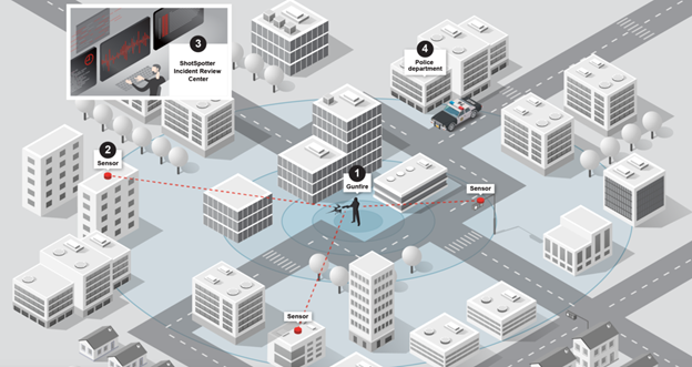
Image courtesy of ShotSpotter.
Precise location data is necessary to ensure police can respond quickly to the exact area the gunfire incident occurred. In addition to helping authorities on the ground, ShotSpotter has been utilized in the courtroom as evidence. Each noise incident recorded on ShotSpotter is timestamped and georeferenced, which can be crucial when constructing a timeline of events.
Technology like ShotSpotter is making the world a safer place, and it relies on geospatial data to do so. Currently, over 100 U.S. cities use ShotSpotter, and that number continues to grow. ShotSpotter is yet another example of how geospatial data can be leveraged to make the world a better place to be. To learn more about how geospatial information is used in litigation, check out this blog post.


