(Image courtesy of Point of Beginning)
In litigation, a clear explanation of a complex situation can win the case. Though printed spreadsheets, maps, and reports are effective, assembling their disparate facts into a convincing narrative can take up valuable time and resources. Today’s digital GIS capabilities accelerate both analysis and data acquisition, while also improving accuracy.
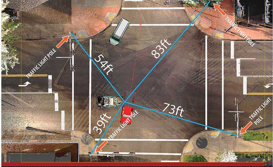
Recreation & Simulation
Recreation and simulation are two of the most convincing ways geospatial data can be used in a courtroom. This is true across the spectrum of litigious issues: from vehicle accidents and personal injuries to medical malpractice and product liability, a litigator’s ability to be clear and accurate is essential.
Site data, orthographic images (aerial images made to reflect actual scale), and topography can be combined to render a realistic depiction of events described by witnesses. By giving decision-makers a visual model of events, litigators help them make more accurate decisions. The interactive nature of these models allows for the court to see an incident from other perspectives, too.
Virtual simulations of events are fashioned out of much of the same information; site data is gathered, then run through a computer-assisted simulation. This is less common, and subject to more stringent vetting to be used as evidence, but is helpful nonetheless. It can be especially useful in lawsuits that involve uncommon activities like repelling or snowboarding, as a tool to reconstruct and animate a sequence of events that may otherwise confuse judges and juries.
Boundary Disputes
In boundary disputes, the value of geospatial data is hard to overstate. Drone mapping has increased accuracy in litigation around these kinds of issues, and not just for big companies or governments.
Organizations like Earthjustice utilize GIS data to aid those in need of advocacy. In 2018, the Pawnee Nation and Earthjustice proved that seventeen oil and gas leases had been illegally approved by the US Government on Pawnee lands. To date, the US Government walked back approval of all but four of those leases.

(Oil tracking image courtesy of Earthjustice)
In Montana, Earthjustice was able to help residents prove that the Bureau of Land Management’s issuance of 287 oil and gas leases did not consider risks to the state’s water and environment. A federal judge reversed the approval. Without access to compelling data, this might not have been possible.
Earthjustice also uses GIS to give the public ways to visualize issues. Their ‘Fraccidents’ map displays all the accidents related to the practice across the country, and, to illustrate the scale of a proposed fracking project, transposed it onto New York City.

(‘Fraccidents’ map courtesy of Earthjustice)
Some of the data and tools used by organizations come from private initiatives, like Esri’s Conservation Program, which connected environmental activists to geospatial resources from 1989 to 2019. The program provided software, training, databases, and connection to experts.
Today, the initiative’s work continues at https://community.esri.com/groups/conservation-gis. There, the work and findings of previous grantees have been compiled in the Conservation GIS Reference Project.
Key Takeaways:
- In litigation, geospatial information is primarily used for either event recreation or data collection.
- The ability to reconstruct or simulate events adds depth and clarity to witness testimony and allows for other perspectives of an incident to be viewed.
- The increasingly widespread availability of GIS data has shortened the technological-capability gap between big entities like governments or companies and smaller ones like Earthjustice or the Pawnee Nation.


