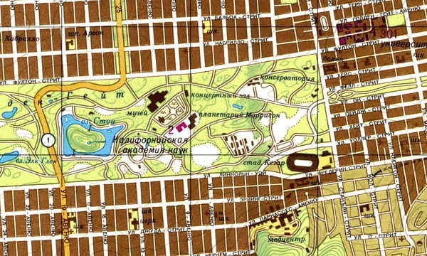
A Soviet map of Golden Gate Park in San Francisco, California.
Following World War II, the Soviet Union set out to map the entire world. The full story of how they did this remains untold, but the legacy of the maps they produced is clear; they are potentially the pinnacle of pre-satellite-era cartography, rich in both aesthetics and diverse data.
Scholars and researchers have used the maps to gain perspective of the USSR worldview. Some argue that the combination of topography with human infrastructure represents an attempt to synthesize the two and express a post-revolutionary worldview. From a more practical standpoint, the map’s content points to potential objectives; from invading (or defending) to understanding.
The maps feature topographic and geographic features, but the amount of auxiliary information they contain is astonishing. Widths of streets, sizes of buildings, and even construction materials and conditions of roadways are recorded in cities around the world. In mountainous regions like Afghanistan, maps include notes on times of year when snow clears from mountain passes. In other areas, maps note where to find edible vegetation and drinkable water. Some even feature the inclusion of military and research facilities that do not appear on official maps from the surveyed country.
In 2005, East View, which has assembled the world’s largest single collection of these maps, translated and published a Russian military manual that provides instructions for how the maps are to be used in planning and executing operations. Tables in the manual provide even more detailed information, like how far certain sounds travel in a given area, even accounting for what kind of material the sound was made on: everything from an idling tank to footsteps to a snapped tree branch.

A Soviet map of the Pentagon in Washington, D.C.
Some of the Soviets’ quest for granular detail in their maps must have come from their military strengths. While the United States Air Force maintained air superiority, Russian forces relied on tank and ground forces. While the Americans were able to formulate a strategy from the sky, the Soviets needed maps that allowed them to plan for more precise ground operations. Typically, 1:50,000 is an ideal scale for such activity.
The Soviet military’s mapping of worldwide urban centers was unparalleled until the arrival of Google Maps. Thousands of cities are mapped at scale 1:10,000 and 1:25,000 – and comprehensively so, not just potential military targets. The detailed mapping of cities like Washington, DC, New York, San Francisco and Seattle are perhaps expected by an adversary. But Pueblo, CO, Madison, WI and Shreveport, LA – points to an obsession within cataloging and measuring American postwar industry and business strength.
The maps were made using a combination of existing official sources (similarities to maps produced by the Ordnance Survey and by US Geological Survey are too numerous to be coincidental), on-the-ground surveyors, reconnaissance aerial photography, and, presumably, spies. Teams were sent out to some of the furthest corners of the earth in pursuit of cartographic knowledge, and some died in their pursuit. Russian cartographer Alexy Postnikov, who, when on assignment to survey a remote area of Yakutiya in the 1960s, found an inscription left by an ill-fated cartographer from 1948. It was left 200 km away from the nearest populated area and stated that he and an injured aide were alone without supplies and fending off bear attacks.

A 1980 Soviet map of San Diego naval facilities (left) compared with a US Geological Survey map of the same area, from 1978 (revised from 1967).
Regardless of the maps’ purpose, it is clear the Soviet government regarded them as precious. Access to them was highly restricted. A strict system of checking out the maps existed, and ex-military members describe feeling that, even if it had been partially or totally destroyed, whatever pieces remained needed to be returned.
When the Soviet Union fell and laws changed, officials and others with access to them started marketing the maps bit by bit to a scattered constellation of buyers, which is how the world knows about them today.
“What remains most impressive about the Soviet maps was their uptake and utilization by industries far and wide – both commercial and consumer”, notes Jonathan Thompson, Director of Sales & Marketing for East View Geospatial. “From telecom and utility to aviation and insurance companies, as well as recreationists and historians alike, these maps have been and continue to be highly regarded and used for countless applications. In fact, for some regions of the world, they still represent the highest quality published topographic information.”
More information about the maps is available in The Red Atlas, a book by John Davies and Alexander J. Kent, which gives an in-depth history of their creation and use. We also recommend reading “Inside The Secret World of Russia’s Cold War Mapmakers” by Wired. East View had the opportunity to contribute their knowledge of Soviet mapping in both The Red Atlas and the Wired article.
For those wanting to dive into the depths of these maps, East View Geospatial’s MapVault service provides access to our vast collection of Soviet mapping as a web mapping service. Each map is available individually in a variety of print and digital formats at shop.geospatial.com.
As cartography continues its march into the future with computer and satellite-aided tools, the painstaking efforts of those Soviet topographers, surveyors, and others will continue to provide an example of outstanding tradecraft whose relevance and value continue to find new applications.


